3.3 The role of ENSO-related tropical heating on operational weather forecasts
The crucial role of tropical heating in the evolution of at least some extratropical weather events is evident in a study of the effect of the 1997-98 El Niño on the operational 1-14 day ensemble forecasts. This study was motivated by the hypothetical question: What would happen to the medium-range (up to 14-day) forecast if the anomalous tropical SSTs were replaced by climatological values? The difference of such forecasts from those made with the actual SSTs- "the ENSO signal"-could then be used to diagnose the influence of El Niño or La Niña on evolving midlatitude storm systems. Because of the uncertainty inherent in weather forecasting, we used the operational MRF ensemble to look at the average of many forecasts of a given storm. The ensemble also provided us with a rigorous way of assessing the statistical significance of our results. It is perhaps worth mentioning that the ensemble with climatological SSTs was run in-house at CDC in real time. Results from the comparison with NCEP's operational ensemble with actual SSTs were made available to public on the web, also in real time.
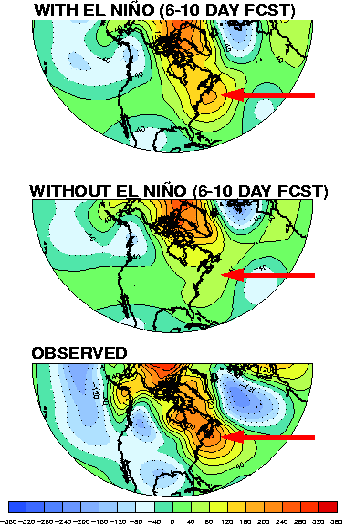
This study provided the first demonstration of a direct impact of El Niño SST anomalies on individual extratropical weather systems. Perhaps the most interesting case was the devastating ice storm that hit Canada in early January 1998. Figure 3.7 shows the predicted 500 mb ensemble-mean height anomaly patterns with and without the El Niño SST forcing, as well as the observed verification. The forecast was a lot closer to the observed with the El Niño forcing included, showing that it played an important role in the evolution of this storm. The area of unusually warm mid-level air associated with the production of freezing rain is indicated by the red arrow. The operational runs (with El Niño SSTs) show a wavetrain aligned along the Atlantic Coast of the United States that is nearly absent in the runs without the El Niño forcing. This wavetrain appears to have been a product of convective forcing in the eastern tropical Pacific interacting with a deep midlatitude/subtropical trough over Mexico: a previously unnoticed mechanism for El Niño teleconnections.
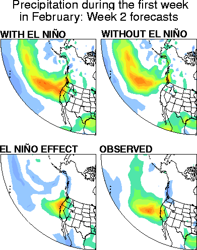
The much-anticipated "El Niño rains" in California provide another example. California rainfall is episodic, even during El Niño years. Rain also falls during non-El Niño years, making attribution of an individual storm to El Niño nearly impossible using historical data alone. However, our use of a dynamical model allowed us to make the attribution directly. In Fig. 3.8 the runs with and without the El Niño forcing differ substantially. The "El Niño effect" is a clear eastward extension of the rainfall into California.
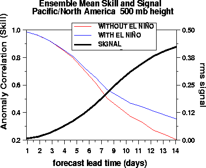
We conducted a similar study for the following winter, during which there was a substantial La Niña event. However, the results were less conclusive, partly because of model changes and partly due to the weaker SST forcing. Nonetheless, over the course of these two winters this experiment provided evidence of a large influence of tropical convection on medium and extended-range forecasts in midlatitudes, especially in Week 2. Figure 3.9 shows that the tropical influence on forecast skill became significant after Week 1 in this experiment, and was responsible for almost all of the skill by day 14. This study also underscored the great difficulty, but also the great rewards, of using an operational forecast model in research mode. As an added benefit, we were able to assist NCEP during their fire-related computer outage by running the operational ensemble forecasts at CDC in real time.