The Role of Springtime Arctic Clouds in Determining Autumn Sea Ice Extent

October 5, 2016
Advance forecasts of late-summer sea ice conditions are important for effective seasonal planning for a diverse set of activities in the Arctic, such as transportation, energy development, and resource management. Accurate predictions on the scales of several months are highly desirable, but these lead times are particularly difficult to achieve.
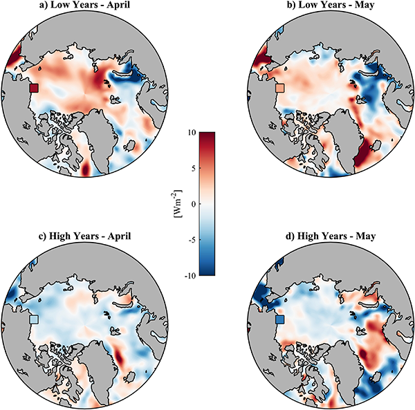
Researchers have recently found that annual variations in the atmosphere during spring can significantly impact the seasonal melting of the sea ice. One possible explanation is that atmospheric conditioning of the sea ice in April and May, a general warming and change in structure of the ice pack, primes it for melt in early fall. Some of this conditioning energy is likely associated with atmospheric transport of warm, moist air from the north Pacific. The air masses themselves are partially responsible for conditioning, but a new study, published in the September 2016 issue of the Journal of Climate focuses specifically on the role of clouds are transported or which form in the air masses. Clouds can play dual roles in the system, providing either a warming or a cooling effect depending on the circumstances.
"The influence that clouds have on the cryosphere is particularly complex during the spring transition season. Our findings indicate that particular attention needs to be given to the precise timing of events during this critical time period," said Christopher Cox, the study's lead author who is a CIRES researcher at ESRL's Physical Sciences Laboratory.
The study focused on isolating the signal of year-to-year variability, rather than on the long-term trend in the seasonal minimum sea ice extent, which decreased substantially over the study period. Results suggest that increased cloud cover in early spring followed by decreased cloud cover in late spring maximizes the relative warming provided by clouds and are thus the springtime ingredients for a year with a relatively low sea ice extent in September. If clearer-than-average skies occur early in spring, and it is cloudier later, higher-than-average sea ice extent is more likely to prevail.
During the 22-year record of data examined (1993-2014), the four highest and four lowest ice years all had the right combination of ingredients, consistent with the scenarios above. In years that didn't follow those patterns, sea ice levels were found to be closer to average. That was true even when calculations of the energy provided by the clouds integrated throughout the spring period were either significantly large or small, suggesting an indirect influence of clouds on turning the dial up or down on feedbacks.
The new study relies on observations made at ESRL's Global Monitoring Laboratory (GMD) station in Barrow on the northern coast of Alaska. Surface-based measurements from Arctic land observatories are the only direct long-term observations of these processes that are available, but the existing network of measurements is sparse.
"Surface-based measurements in the Arctic are extremely valuable. We must be creative in using these data sets to inform problems such as determining how springtime clouds influence autumn sea ice extent," said Cox. "It appears that Barrow is situated in a region over which the atmospherically influenced air masses pass before they reach the sea ice. Therefore, we believe that Barrow is an important location for providing insight into the conditioning problem."
This study provides further evidence of the importance of improving representation of clouds in models. Improving understanding of early-season influences on late-season sea ice conditions has the potential to increase predictive skill of forecasts at lead times of 3 to 5 months.
CONTACT
- Christopher Cox, lead author and PSL researcher, (303) 497-4518