Moisture pathways through western U.S. mountains more likely to cause extreme wintertime precipitation
Two complementary studies led by NOAA and CIRES researchers from the NOAA/ESRL Physical Sciences Laboratory (PSL) explain how atmospheric moisture can traverse the high terrain and complex topography near the U.S. West Coast in sufficient amounts to produce extreme precipitation events in the Sierra Nevada and in the Intermountain West (IMW). The results appear in the June issue of the Journal of Hydrometeorology.
"What's interesting is that these two studies were done independently using different research techniques," says PSL researcher Allen White. "And although one focuses on a relatively small area, and the other on a much larger expanse, the results support each other."
White is lead author of one of the studies, which concentrates on a field site in the northern Sierra Nevada mountains.1 Conditions at this particular site behave more like those found at a coastal site – in terms of the observed precipitation characteristics, such as drop size, and the vertical structure of clouds.
"For years we've been studying a shallow precipitation process (precipitation that forms closer to the ground) that is difficult to detect with operational radar," says White. "We thought this process occurred mainly near the coast but, as discovered in this study, the northern Sierra site behaves similarly."
The site also tends to receive more precipitation than a similar-elevation site in the southern Sierra. Using data from NOAA's Hydrometeorology Testbed and CalWater field programs, White and his team found that these conditions are caused when the moisture-rich air contained in atmospheric rivers flows through a substantial gap in the coastal mountains associated with the San Francisco Bay area. In contrast, the southern Sierra site receives marine air flow that has been at least partially rained out as it passes over steep coastal terrain.
"It's no surprise that California's largest reservoirs are located toward the north end of the Central Valley because climatologically that region receives more wintertime precipitation than other parts of the State," says White. "We now know that this gap in the terrain plays a key role in delivering moist air flow, which enhances the precipitation falling in the region."
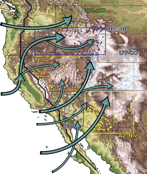
The other study,2 led by PSL's Michael Alexander, broadens the geographical impacts of moisture transport to the IMW – an area spanning much of the western U.S. between the Washington and California mountain ranges to the west, and the Continental Divide to the east. Although typically arid, the IMW can sometimes experience winter storms that bring heavy precipitation and lead to severe flooding.
"Mountains block airflow and cause it to rise, and as the air rises it expands and cools," says Alexander. "Because cooler air holds less moisture, the moisture falls out as rain or snow as it passes over a mountain range – a process called 'orographic precipitation'. Once the air moves down the backside of the mountain it will contract, which contributes to the relatively warm, dry conditions in the IMW".
However, Alexander and his team found that when moisture from the Pacific takes certain paths through gaps in the Washington-Oregon Cascade mountains and California's Sierra Nevada and Peninsular mountains, it can potentially lead to extreme events in parts of the IMW.
"When unobstructed, the moisture doesn't ‘rain out'," says Alexander. "The pathways in the mountains funnel the moisture associated with storms into the IMW."
Although topography clearly influences the moisture transport and precipitation in the IMW, it is large-scale atmospheric patterns, such as atmospheric rivers, that create the conditions necessary for heavy winter precipitation to occur.
For both studies, tracking how moisture travels and builds along these pathways can provide better understanding of the processes that cause heavy precipitation and potentially lead to flooding. This type of information can be used to improve short-term forecasts and inform decision makers, such as water managers and emergency planners, which helps keep communities safer.
Acknowledgements
Financial support for the Alexander et al. study was provided by the Reclamation Science & Technology Program, with interagency collaboration fostered through the Climate Change and Water Working Group.
Posted: July 13, 2015
1White, Allen B., Paul J. Neiman, Jessie M. Creamean, Timothy Coleman, F. Martin Ralph, and Kimberly A. Prather, (June 2015): The Impacts of California’s San Francisco Bay Area Gap on Precipitation Observed in the Sierra Nevada during HMT and CalWater. J. Hydrometeor., 16, 1048–1069. 10.1175/JHM-D-14-0160.1
2Alexander, Michael A., James D. Scott, Dustin Swales, Mimi Hughes, Kelly Mahoney, and Catherine A. Smith, (June 2015): Moisture Pathways into the U.S. Intermountain West Associated with Heavy Winter Precipitation Events. J. Hydrometeor., 16, 1184–1206. 10.1175/JHM-D-14-0139.1

- Related Links
- Reclamation Video
- PSL's Atmospheric River Portal