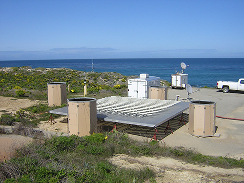
An Atmospheric River Observatory on San Nicholas Island, CA. (Photo credit: Tom Ayers, NOAA)
|
Four Coastal Atmospheric River Observatories to be Installed Along Central California Coast
February 28, 2013
NOAA/ESRL's Physical Sciences Laboratory will install the first of four coastal Atmospheric River Observatories (AROs) along the central California coast in March 2013 as part of the NOAA Hydrometeorology Testbed (HMT) legacy project sponsored by the California Department of Water Resources. The ARO will be located at the University of California's Bodega Marine Laboratory in Bodega Bay. By the Fall of 2013, three additional AROs will be installed; one along the northern coast of California at the Arcata/Eureka Airport in McKinleyville, one along the central coast at the U.S. Navy's facility in Pt. Sur, and one along the southern coast at the Santa Barbara Airport in Goleta. A fifth ARO supported by the U.S. Navy is on San Nicolas Island, located approximately 70 miles southwest of Los Angeles.
Atmospheric Rivers (ARs) are relatively narrow regions in the atmosphere that are responsible for most of the horizontal transport of water vapor outside of the tropics. When ARs strike land, they produce heavy precipitation that can lead to flooding. Satellites and numerical models are able to track ARs over the oceans, but the satellites do not measure the winds aloft that focus the transport of moisture onshore and help to determine just how hard it is going to rain, as well as which watershed(s) will be impacted most by the AR. Numerical models often struggle with the timing and location of ARs making landfall and may not represent relatively small-scale features in the parent storm that cause the AR to stall over a particular area, further exacerbating the flood risk.
The network of AROs will help weather forecasters, emergency and water managers, and the general public detect and monitor AR conditions. The ARO consists of a ¼-scale 449-MHz Doppler wind profiler, a GPS receiver for integrated water vapor retrievals, and a surface meteorology station that includes a rain gauge. NOAA NWS and ESRL also operate rain gauges in the coastal mountains downstream from each ARO to determine the rainfall enhancement caused by the sloping terrain. Data from the AROs are transmitted to a data hub in PSL, where display products are generated and disseminated online. An AR-focused water vapor flux tool allows weather forecasters to see how well computer generated weather forecast model guidance is portraying the AR conditions. The tool also uses thresholds in upslope wind speed, integrated water vapor, and water vapor flux established by HMT research to indicate the severity of the AR conditions. The ARO also provides measurements of the snow level, or the altitude where falling snow changes into rain. The snow-level is significantly higher in AR conditions than in non-AR conditions, which becomes a greater concern if and when the AR reaches the Sierra Nevada, where runoff is more highly dependent on the snow level.