The RITS Ocean Cruise of 1989The peak analysis outputs of chromatograms measured from air and surface water equilibrator samples collected during the RITS Discovery Pacific Ocean Cruise of 1989 have been used to compute atmospheric and surface water concentrations of the following compounds: N2O, CFC-11, CFC-113, CH3CCl3, and CCl4.
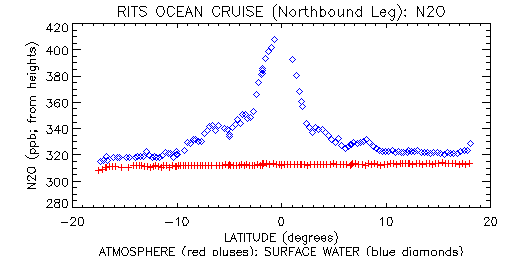
Shown below is a plot of the atmospheric and surface water concentrations of N2O measured during the ship's northbound equatorial crossing. The N2O plot shows the relative abundance of N2O in the warmer surface waters near the equator. The concentrations computed to date remain preliminary.
|
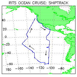 Shown at right is a plot of the shiptrack. The ship originated in Seattle
and initially travelled southward along the North American coastline with
ports in San Diego and Manzanillo. From there it travelled due South
over open water along the 105th meridian to 61° S latitude
before returning northward to Seattle along a more westward route. Two
ports during this open water segement were at Easter Island and Tahiti.
Shown at right is a plot of the shiptrack. The ship originated in Seattle
and initially travelled southward along the North American coastline with
ports in San Diego and Manzanillo. From there it travelled due South
over open water along the 105th meridian to 61° S latitude
before returning northward to Seattle along a more westward route. Two
ports during this open water segement were at Easter Island and Tahiti.