Weather Forecasts
Daily Weather Summary
June 17, 1999:
Weather continues to be nice for set up. Cool weather to continue. Highs in the mid to upper 70's. Winds from the north at 8-12kts. A small vorticity max will move through early today but with little chance for precip because of little available moisture. The shortwave will energize a low on the now stationary front running through Alabama and Georgia eventually kicking this feature out as a cold front with a new low forecasted to form off the coast (sounds like a Jan forecast).
Tomorrow's Forecast
June 18, 1999:
Weather will continue to be cool with max temps near 80. Winds will lighten a bit to near 10 kts and be a bit more northeasterly. Skies should be crystal clear except for a few fair weather cumulus near max temps.
Day after Tomorrow Forecast
June 19, 1999:
As the surface high slowly moves east winds will gradually clock to be more easterly. Winds will lighten as the axis of the high moves closer. Gradually temps will warm into the low 80's. Skies will remain mostly clear.
Outlook
June 20 - 23, 1999:
The upper level trough continues to hang over the eastern U.S through the early part of next week. Finally by Wednesday of next week the longrange models produce ridging over the mid-eastern U.S. This should give warmer temps into the low 90's and winds from the south to southwest.
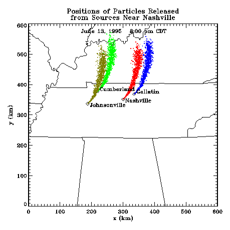
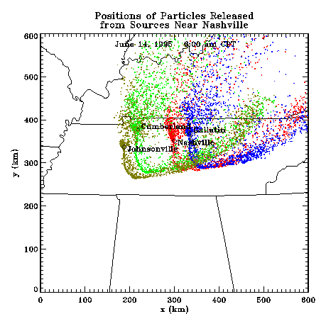
Profiler Plume Depiction
The following shows a depiction of plume locations as predicted by the profiler winds assimilated into a one-dimensional boundary layer model. The top image shows particle positions as of 8:00 PM CDT for particle releases beginning at 12:00 Noon. The lower image shows particle positions at 7:00 AM CDT for particles released beginning the previous noon.