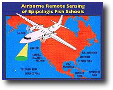
FLOE can be used to survey many types of fish in North America.
|
Oceanographic (Fish) Lidar
"How many fish are there?" is an important question in managing
any fishery. Traditional methods of answering
this question include direct sampling, egg sampling, sonar survey, and
aerial survey. Each has its limitations. Perhaps the most severe limitation
of the surface-based techniques like sampling and sonar is that ships
are slow. Only a small fraction of the possible habitat can be surveyed,
and the cost is high. Aerial surveys can cover a much larger area of the
ocean, but the data are less reliable. The data consist of estimates made
by expert observers; the accuracy of these estimates varies from observer
to observer and also from day to day as surface and illumination conditions
change.
ETL is developing an airborne lidar for
fisheries surveys (named FLOE for Fish Lidar, Oceanic, Experimental),
in cooperation with the National Marine
Fisheries Service (specifically, with the
Southwest Fisheries Science Center ) and
Alaska Fisheries Science Center.
The system will use a pulsed
lidar to profile fish density from a small aircraft. The basic technology
was developed by the Department of Defense to detect other objects in the
water. The
data do not depend on the skill of the observer or on the
conditions at the surface, and are thus of much more uniform quality.
How does it work?
LIDAR is an acronym for LIght
Detection
And
Ranging.
In its simplest form, a short pulse of laser light is directed toward a
target. A receiver is pointed in the same direction and waits for a return
signal reflected from the target. The elapsed time indicates the targets
range. The strength of the return provides additional information about
the target. In this case, the target is schools of fish swimming in the
ocean. By putting a compact Lidar system in a small airplane we can fly
over large areas of the ocean and determine how many fish there are in
that section of the ocean. The system will work best on the upper ocean
fishes, such as anchovy, sardine, mackerel, and herring. The cost is less
than 10% of a ship survey per survey kilometer, and the depth penetration
is more than 3 times that of a visual survey.
What does the lidar look like?
Details and photos of the lidar are given
on the instrument page.
What aircraft has it flown on?
We have flown on a variety of aircraft.
The requirements are for a downward-looking port with a diameter of 30
cm, allowance for about 200 kg for the equipment, and at least 1000 W of
available electrical power. Photos of the installation can be seen for
a Partenavia Observer,
a Beechcraft King Air 200,
a King Air 90,
a Casa,
a Rockwell Aerocommander,
a Cessna Cardinal,
and a DeHaviland Twin Otter.
Is it calibrated?
For survey purposes, we would like to convert
the lidar signal into a depth profile of the biomass density for each species.
This means that we need to know the reflectivity of each target species
and we need to be able to identify the species responsible for our signals.At
this time, laser reflectivity measurements have been only made on one species
of live fish, sardines (Churnside, et al.1997),
although more measurements have been using frozen fish in the laboratory
(Churnside, 1991).
Species identification cannot be done unambiguously
using only the lidar signals, and other clues must be considered. The lidar
can tell the difference between large fish like tuna and salmon and small
fish like sardines and herring. The habitat being surveyed generally eliminates
most species from consideration. The most important factors are depth in
the water column and latitude. In many cases, we rely on visual observations
from the air and on ship reports. In these cases, we have to assume that
the distribution of species is similar where we do not have this information.
Is the laser safe?
The laser beam is expanded to meet the
1993
ANSI standards for occupational laser safety at the surface. We also
avoid illuminating boats by momentarily blocking the beam as we pass over.
We have also investigated the potential
hazard to marine mammals (Zorn, et al.)
for 13 species of cetaceans and pinnipeds. We found that all of these were
considerable less sensitive to laser illumination than humans and therefore
not at risk from our lidar. There are no species that are expected to be
more sensitive than the ones examined based on available information. Other
marine creatures are expected to be even less sensitive than marine mammals
from what we know about their visual systems.
What has it seen?
The lidar has, or will have, been used
in a number of field trials. More details can be found by clicking on the
location and year for Florida, 2000; Alaska,
2000; Spain and France, 1999; California,
1999; Spain, Portugal, and France, 1998;
Washington
State, 1997; California, 1997; and
the California, 1995 ship tests.
The target species have generally been sardines and anchovies, although
the 1999 California flights were looking at squid, and the Washington flights
were looking at herring. We are continuing to add results as we continue
to work with the data.
|