NOAA's Hydrometeorology Testbed
Innovations for extreme precipitation information

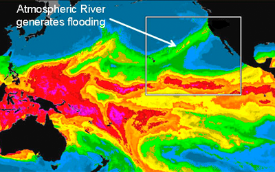
They've been called the "Katrinas of the West"—atmospheric rivers of moisture-rich air can sweep up from the tropical Pacific and dump deadly winter storms on the West Coast of the United States. This past winter was the Hydrometeorology Testbed's (HMT's) sixth in California. HMT deploys customized instruments and develops advanced tools and methods to improve understanding of wintertime storms–and how they may be changing with climate change.
In the last several years, HMT scientists with the NOAA Earth System Research Laboratory (ESRL) Physical Sciences Laboratory set up Atmospheric River Observatories on the California coast and further inland to track and study atmospheric rivers, which satellites can only follow over water. An atmospheric river combined with strong upward air motion could mean a storm capable of causing floods. "HMT is helping us figure out what it takes to understand high-impact weather events, both to save lives threatened in storms, and to understand what the future holds..." said HMT Project Manager, Tim Schneider.
During their studies in California, ESRL has developed strong relationships with state agencies, universities, and staff at several Weather Forecast Offices and two regional River Forecast Centers. These interactions have facilitated one major goal of HMT work: The transfer of promising experimental instrument and modeling systems into the hands of operational forecasters. "The knowledge HMT has given us is situational awareness," said Dave Reynolds, Meteorologist in Charge-NWS Monterey Forecast Office. "I can see what is coming, and I can prepare my customers—particularly emergency managers—for what is coming."
HMT goes beyond weather, too. ESRL scientists have been collecting observations and studying U.S. West Coast winter storms for more than a decade as part of a larger effort to understand the role of climate variability and change on coastal extreme events.
Although HMT-West has concentrated on California, researchers are confident that lessons learned there can be applied to the Pacific Northwest, where atmospheric rivers can also trigger major problems in wintertime. "We have the same phenomenon, but different geography," said Schneider.
Last year, the U.S. Army Corps of Engineers discovered leaks in Washington State's Howard Hanson Dam, which could turn disastrous should a large winter storm bring heavy precipitation to the region and stress the dam and downstream levees. The Army Corps needed better observations and forecasts until the dam can be repaired. Since ESRL had recently deployed a new Mobile Atmospheric River Monitoring System on the Washington Coast at Westport to study atmospheric rivers, they became involved in developing a plan to help monitor conditions near the dam. ESRL installed atmospheric river observing equipment at two nearby sites to measure wind, snow level, and water vapor. The National Weather Service set up 14 additional rain gauges near the dam. With data streaming in via the internet from the new equipment, NWS forecasters are able to monitor land-falling winter storm observations on the coast and compare them with conditions experienced closer to the dam. The data from this equipment is helping forecasters provide improved decision support services to the Army Corps and emergency managers.
ESRL's numerical modeling experts also play a critical role in HMT. Back in Boulder, Isidora Jankov, Steve Albers, and colleagues in the Global Systems Division gather together all available observations—from HMT's custom instrument suites to conventional meteorological data gathered in both California and Washington regions—and use it to fire up forecast models.
"See that blue? That's enhanced moisture flux moving toward the coast," Jankov said, pointing to her computer screen last month. "That's going to hit Seattle tomorrow, but today, it's hitting Vancouver. They're going to get some heavy rain."
The modelers are producing some of the longest-lead-time high-resolution forecasts ever for the California and Pacific Northwest regions, Jankov and Albers explain, and they are mixing-and-matching different physics, dynamics, and initialization schemes to create ensembles. (Model ensembles are widely recognized as able to produce more skillful forecasts than single, or "deterministic" model runs).
"We are using these ensembles for quantitative precipitation forecasts and probabilistic quantitative precipitation forecasts," Jankov said. The runs rely on ESRL's supercomputing resources, and ensemble forecasts for HMT are run every six hours.
Jankov and Albers say they are working closely with the HMT team, including CalWater, River Forecast Centers, and the National Weather Service, to figure out what combinations of model components and ensemble methods will produce the best model-based precipitation forecasts. The researchers are especially interested in accurately forecasting when and where rain turns to snow, or vice versa. "This is very helpful information for the water managers who are predicting runoff," Albers said.
The still-experimental forecast systems may eventually become operational, he and Jankov said. "In a year or two, we will have something that stays in the Weather Forecast Offices, a legacy of HMT."
HMT will eventually establish other major regional efforts – focusing on the climatology and weather processes affecting extreme precipitation and flooding in other flood-prone parts of the nation. While committed to maintaining "legacy" activities in the West, the next focus region is the Southeast U.S. In addition to winter storms, the Southeast U.S. has its own complex set of problems when it comes to flooding: ice storms, heavy spring rains and the June-November hurricane season.
By Barb DeLuisi and Katy Human, Winter 2009/10

- Related Links
- Hydrometerology Testbed
- Atmospheric River Info Page