 |
Water Cycle Branch Overview
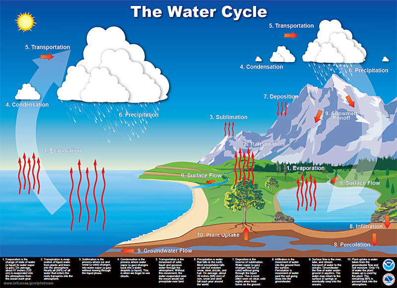
Water is a vital, life-sustaining resource, yet the water cycle remains one of the grand science challenges within NOAA and for society, in general. In a formal planning process, NOAA identified "Improve understanding of the water cycle at global to local scales to improve our ability to forecast weather, climate, water resources and ecosystem health" as one of just six NOAA Grand Science Challenges.
The Physical Sciences Laboratory's Water Cycle Branch (WCB) represents a core capability for scientific and technological innovation that advances water cycle science and services in NOAA. WCB combines expertise on the hydrometeorological processes affecting weather and climate with world-class observing system science, numerical modeling, forecasting techniques and familiarity with the critical needs related to a broad array of water information requirements and gaps.
WCB's team of roughly 35 scientists, engineers, and support staff facilitate and conduct research focused on improving scientific understanding and prediction of extreme hydrometeorological events, and prototypes within NOAA's Hydrometeorology Testbed (HMT) new tools and methods to support monitoring and prediction of heavy precipitation and flooding. This requires expertise in the areas of precipitation processes and forecasting, hydrologic modeling, the capabilities and limitations of observing systems, and the relationship between short-term climate variability and significant weather events. Extensive experience in the design and use of regional networks of ground-based and airborne remote sensors, conventional in-situ observations, and satellite data has been applied to numerous field research programs. To pursue these challenges, the WCB is organized into two teams, the Hydrometeorological Forcings Science Team, led by Dr. Robert Cifelli, and the Observing System Science Team, led by Dr. Clark King.
The work of the WCB is informed by NOAA's Mission requirements including the needs of many users of water information. For example, the emerging National Water Center requires state-of-the-art approaches to provide the "forcings" (i.e., precipitation, surface fluxes, snow information, antecedent soil conditions, etc.) for future stream flow prediction and flood warning capabilities. Conversely, WCB's creative staff develops innovative new approaches that themselves inform water information users of what may be possible in the future.
Role in the Hydrometeorology Testbed
WCB's capabilities and goals are epitomized by its leadership of NOAA's Hydrometeorology Testbed (HMT). HMT conducts research on precipitation and weather conditions that can lead to flooding, and fosters transition of scientific advances and new tools into forecasting operations in NOAA. Outputs support efforts to balance water resource demands and flood control in a changing climate. HMT research has led to a better understanding of the forcings of extreme precipitation events, and, in particular, the role that atmospheric rivers play in creating floods. The success of HMT in a watershed upstream from Sacramento, California, led to a five-year project with the California Department of Water Resources to implement HMT findings throughout the State.