6.4 Western Water Assessment: A Regional Integrated Assessment for the Intermountain Western United States
CDC has collaborated with researchers from CIRES and the University of Colorado to develop the Western Water Assessment (WWA), an interdisciplinary research project linking climate, water resources, and society. The project is designed to do integrated interdisciplinary research and to interact with users in an effort to ensure society relevant research. The WWA, funded through the NOAA/OGP Regional Integrated Sciences and Assessments (RISA) program, represents an effort to forge genuine partnerships among the scientific community, climate service providers, and users. The goal is to provide the relevant climate/hydrology information that will support informed decision-making and thus reduce vulnerability to the impacts of climate variability and change.
CDC's WWA research has focused on the role of climate information for the decision-making process for water managers in the Upper Colorado River Basin. Colorado and the Interior West are ideally suited for a regional focus since the climate conditions (e.g., snowpack, timing of peak runoff, and extreme events) are orographically controlled. Investigations have evaluated the use of existing suites of climate predictions and products by the region's decision makers for specific sectors, and have undertaken the task of developing new products, or adding value to existing ones. The effort involves frequent interactions with users through regular briefings, workshops, coordination meetings, or web-enabled tools. The applied climate research aims to provide an improved regional description of climate and its variations on spatial and temporal scales that are relevant to users. Applied hydrologic research examines the role and evolution of snowpack, and identifies those predictable weather and climate patterns that influence variability in regional hydrographs.
6.4.1 User interactions
Over the past two years, CDC scientists have worked with managers of reservoir operations in the Upper Colorado to determine how climate information might be used more effectively throughout the water year. These user studies involved: a) direct participation in planning by attending and or hosting reservoir management meetings, b) partnering with the Denver Water Board and Colorado River Water Conservation District to hold a workshop focused on the use of climate information and seasonal forecasts in water resource management focused on endangered fish habitat restoration, c) preparation of "Climate Forecast Discussions for the Upper Colorado Basin" for distribution to USBR and other interested water managers, d) providing briefings on climate forecasts and current status to the Colorado Drought Task Force and various water resource coordination meetings for the Upper Colorado Basin, and e) focused user studies described previously. These activities, while labor intensive, have established the needs and potential uses of forecasts and climate information in water resource management. The next step will be to incorporate climate forecasts and information into the NOAA Colorado Basin River forecasts used by reservoir managers. On-going activities are focused on implementing a technology transfer process to integrate seasonal climate information into river forecast procedures. A collaborative effort with the Colorado Basin River Forecast Center, in Salt Lake City is envisioned following an iterative process of identifying prototype climate products needed by the River Forecast Centers and then developing applied climate research products.
6.4.2 Regional climate variability
Identified user needs and interests in regionally based climate information have helped motivate research to enhance understanding of climate variability in the intermountain western US. CDC researchers have performed empirical analyses on western U.S. precipitation patterns (derived from historic climate station and automated SNOTEL data) at a number of spatial and temporal scales to document and provide insights into patterns of observed range of climate variability. These analyses have concentrated on the South Platte and Upper Colorado River basins, and have also assessed higher elevation climate records relative to more continuous low elevation sites (Fig. 6.10). Results for Colorado reveal relatively low temporal variability in the regionally important winter precipitation season at high elevations (red/orange colors), which contrasts with more variable winter precipitation at lower elevations (blue/green) colors.
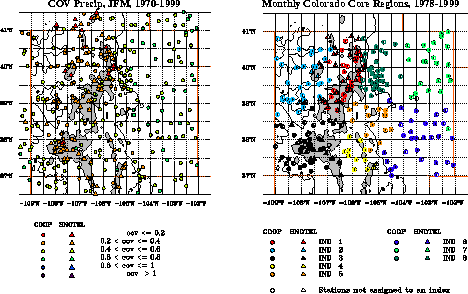
CDC researchers also developed hydroclimatically based experimental "climate divisions" using multivariate analysis of the annual cycle of precipitation in order to improve monitoring of the seasonal evolution of precipitation across Colorado (Fig. 6.10). The resulting experimental "climate divisions" regions explain more than half of the average local precipitation variance. Since each regional average explains more precipitation variance than the operational divisional time series, these internally consistent experimental regions are proposed as alternative to existing climate divisions to monitor the seasonal evolution of precipitation.
6.4.3 Regional hydrologic variability
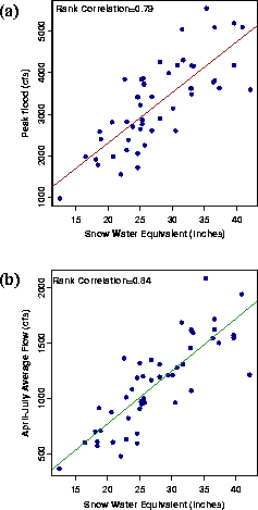
Identified user needs and interests in regionally based climate information also have helped motivate research focused on the potential for predicting the magnitude and timing of late spring/early summer peak runoff. The observed hydrologic regime in the upper Colorado River Basin is driven largely by the cold season snowpack dynamics, warm season melt, and characteristic space-time scales of relevant weather and climate precursors. Seasonal streamflow variations and peak floods in the West reflect an integration of seasonal-to-interannual climate influences (through snowpack development in the cold season) and weather patterns on month-to-seasonal time scales (responsible for snowmelt in the spring). The magnitude and timing of springtime peak streamflow represents the joint influences of the wintertime climate (as reflected in the snowpack), and the springtime weather patterns that aid in the melting of snowpack. Diagnostics and monitoring of intraseasonal-to-interannual hydroclimatic variations in the Yampa River drainage have shown consistent relationships between the April 1 snowpack and April-July streamflow. Analysis of historical records suggests that over 60% of the observed variations in streamflow can be explained by a linear snow-streamflow relationship (Fig. 6.11).
The large-scale climate controls on extreme (high and low) snowpack years in the Yampa River Basin can be interpreted in terms of composite SST anomaly patterns. Low snowpack occurs during winters with anomalously warm tropical Pacific and a cold North Pacific. High snowpack years are associated with warm North Pacific SST and a cold tropical Pacific SST anomalies. Ongoing research is investigating: (a) the associated winter and spring variations in intraseasonal precipitation and temperatures to assess the risk for extreme surface hydrologic variations, and (b) the underlying mechanism for the associated patterns of SST anomalies and their predictability, to aid snowpack predictions.
Streamflow during the April-July melt season is driven by regional temperature patterns that determine the shape of melt hydrograph and the timing of peak flow. The timing of peak flow (or annual maximum flood) is critically important for reservoir operations and assessing downstream flood potential. Preliminary analysis suggests a causal relationship between the regional temperatures and the timing of peak flow. In the Yampa region, a three-to-five day lag is observed between the temperature and snowmelt-driven streamflow. Further, the amplitude of Eastern Pacific and Pacific North American teleconnection patterns (April) show a statistical relationship with the date of peak streamflow. The results from these analyses point to the potential for modeling and forecast of snowmelt and the timing of peak flows, based on a detailed analysis of medium-range temperature variations and available forecast products. Near real-time monitoring of the relevant hydroclimatic variables and CPC temperature forecasts for the Yampa region are now available on the WWW (http://psl.noaa.gov/~sjain/waterpulse/).