Drought Index Evaluation and Implementation
August 17, 2009
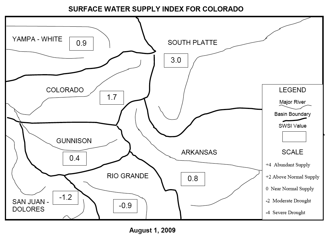 Current version of the Surface Water Supply Index (SWSI) for Colorado |
The National Integrated Drought Information System (NIDIS) and the Earth System Research Laboratory (ESRL) will host a planning workshop for a new project entitled "Drought Index Evaluation and Implementation in a Geospatial Framework Linked to Hydrologic Data Web Services." The workshop will be held August 18-19, 2009 in Boulder, CO. The purpose of the meeting is to draw up a work plan for reviewing the conceptual basis of the Surface Water Supply Index (SWSI), and develop a more modern and flexible implementation that builds on recent achievements in geographic information infrastructure and web services. This initial meeting will focus on the Upper Colorado River Basin. Participating organizations include US Geological Survey, Colorado Water Conservation Board, Northern Colorado Water Conservancy District, Natural Resources Conservation Service, Colorado State University, University of Colorado, Utah State University, Western Regional Climate Center, and the National Drought Mitigation Center.
The SWSI was originally developed in the 1980s for use as a composite water supply indicator for specific basins in Colorado, Utah, and Wyoming. Calculated using reservoir storage, precipitation, snow pack and stream flow data for seven basins in Colorado, many see the need for potential changes in the reservoirs used, implementation for a larger number of smaller basins, and more frequent and timely updates. A NIDIS proposal was recently funded by NOAA TRACS to modernize drought index implementation, beginning with the SWSI, and this workshop is the kick-off meeting for this project.
With a growing population and changes in climate, water availability is of major concern to the public and decision makers. The Drought Response Plan of the State of Colorado makes explicit reference to the SWSI and the surpassing of specific values to trigger the activation of sectoral drought task forces. The Plan is under revision to meet FEMA standards, including a re-examination of the SWSI and its implementation. This project will provide more customizable access to targeted water supply information in the state of Colorado. In addition, this prototype could be applied to other water basins in the western U.S.
| Contact: Jim Verdin | More Information: |