Southern AZ Soil Moisture Observational Network Sites Assigned NWS Station IDs
April 6, 2009
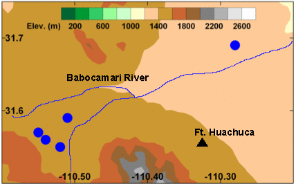 Map showing Southern AZ Moisture Observational Network Sites |
The NOAA Earth System Research Laboratories maintains a Soil Moisture Observational Network across southeastern Arizona's San Pedro River Basin. The two primary goals of this joint NOAA Research (OAR)/National Weather Service (NWS) effort is to use the data gathered by the network to improve NWS flash flood forecasting efforts and to examine ways to use soil moisture information to improve the hydrologic models used by the NWS. The NWS Colorado Basin River Forecast Center (CBRFC) has begun ingesting soil moisture and temperature, rain rate, and basic surface meteorology data from these sites into their operational system. For example rain gage data provides crucial precipitation input into the Multisensor Precipitation Estimate (MPE) product for use in the CBRFCŐs streamflow predictions in this basin. To this end, five of the ESRL-operated Arizona soil moisture stations were recently assigned NWS Cooperative Station Network (ŇHandbook 5Ó) identifiers. These station IDs enable NWS hydrologists to ingest the data set and make it accessible in the Advanced Weather Interactive Processing (AWIPS) system.
Southern ArizonaŐs San Pedro River recharges ground water storage, and provides water for human needs and those of agriculture. In addition, during the North American monsoon season (July-September), heavy precipitation events can cause flash flooding in the San Pedro River basin. The goals of the project include providing a data set that can be used to evaluate the performance of the NWS operational hydrological models. Special emphasis has been placed on the evaluation of the OHD developed SAC-HT distributed hydrologic model run by CBRFC. The closely nested stations located in the headwaters of the Babocomari River will be used to examine the impact of land use and soil type heterogeneity across the basin as well as on scales smaller than the spacing of a model grid cell.
The dry climate and rapidly growing population of the state of Arizona is making management of water resources a challenging task. Accurate soil information is needed to support flash flood forecasts, and to monitor the effects of climate change on the amount of water that can be retained by the soil. The data can also be used for water resource management studies. The Soil Moisture Observational Network originates from NOAAŐs cross-cutting goal of Integrated Water Resource Services. The assignment of NWS Handbook 5 IDs to the OAR/ESRL soil moisture and temperature stations is a crucial first step that facilitates the use of the new data set in the evaluation and improvement of NWS hydrological products and services.
| Contact: Bob Zamora | More Information: |