HMT-West 2007 Underway – A Promising New Experimental Product is Tested
February 12, 2007
 The NOAA Earth System Research Laboratories (ESRL) is currently computing
bulk upslope water vapor flux along the California coastline with a new
real-time product developed for the Hydrometeorological Testbed (HMT)
Program. This experimental product was based on four winters of analysis
and combines information on storm forcing (boundary layer winds aloft)
measured by wind profiling radars and fuel (water vapor) measured by
GPS-Met receivers, and is well correlated with rainfall rates in the
nearby, downwind mountains. The product, which graphically displays the
data and is updated hourly, could potentially become a useful aid for
predicting and assessing precipitation amounts in the mountains of this
area; and is already showing promising results during a large storm that
has recently hit the area.
The NOAA Earth System Research Laboratories (ESRL) is currently computing
bulk upslope water vapor flux along the California coastline with a new
real-time product developed for the Hydrometeorological Testbed (HMT)
Program. This experimental product was based on four winters of analysis
and combines information on storm forcing (boundary layer winds aloft)
measured by wind profiling radars and fuel (water vapor) measured by
GPS-Met receivers, and is well correlated with rainfall rates in the
nearby, downwind mountains. The product, which graphically displays the
data and is updated hourly, could potentially become a useful aid for
predicting and assessing precipitation amounts in the mountains of this
area; and is already showing promising results during a large storm that
has recently hit the area.
Background:
HMT is a NOAA demonstration program designed to aid flood forecasting by
accelerating the infusion of new technologies, forecast models, and
scientific results from the research community into daily operations of the
National Weather Service, including Weather Forecast Offices, River
Forecast Centers and the National Centers for Environmental Prediction.
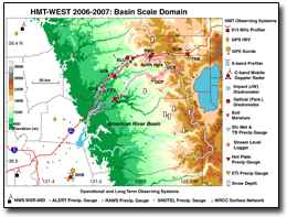
HMT-West, which is currently underway through late March 2007, is in its second full year, with at least two more years planned. This year is focused on collecting more observations at the higher altitudes of the basin, where snowfall is more common. Several research-grade observing instruments from ESRL and the National Severe Storms Laboratory (NSSL) have been deployed to the region. Additional observing systems include raindrop and snowflake disdrometers, various precipitation gauges, soil moisture/temperature sensors, stream level loggers, standard surface meteorological stations, and a radiosonde system. The measured parameters are vital ingredients for accurate predictions of runoff and flooding that are too sparsely available, too distant, or entirely absent for most watersheds. The USGS is also collecting rainwater samples for chemical analysis. New high-resolution weather prediction models from ESRL are also being tested in the project and compared with exiting models used by the NWS.
Significance:
The upslope water vapor flux product could become a useful forecasting tool
that could help mitigate societal impacts from wildfires, flooding, and
debris flows (mud slides). This research supports NOAA's mission goal of
serving society's need for weather and water information.
| Contact: Timothy Schneider | More Information: |