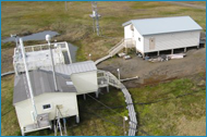
ARM Barrow, Alaska Station
Radar-Based Cloud Microphysical Retrievals
The North Slope of Alaska (NSA) site provides retrievals of cloud water content, and droplet/crystal size based on 35-GHz radar measurements for 1998 through 2003. The input data sets were collected by the Department of Energy ARM Program at the North Slope of Alaska site located at 71° 19.378' North, 156° 36.934' West.
Contributors to this project, as well as information on how these data sets should be referenced and acknowledged, can be viewed in Acknowledgements.
Data Browser

View plots of the following instrument data at Barrow:
- Input radar reflectivity, microwave radiometer liquid water path, and rawinsonde data
- Cloud classification masks
- Ice particle and/or droplet sizes
- Ice and/or liquid water contents
- Radar reflectivity, Doppler velocity and spectral width
- Radiometer brightness temperature, infrared at 10.6-11.3 microns and microwave at 23.8 and 31.4 GHz
Data is also stored in NETCDF format with one file/day. The Version Notes provide important information on how theoretical techniques to retrieve cloud properties were applied to the input data sets. It is highly recommended that the user read these version notes carefully.
A reference section provides information on publications that describe instruments, retrieval techniques, and NASA, DOE, and NSF programs that have supported this work.