SOS 1995 Lidar Findings
Urban Stagnation Study
(i)
(ii)

(iii)
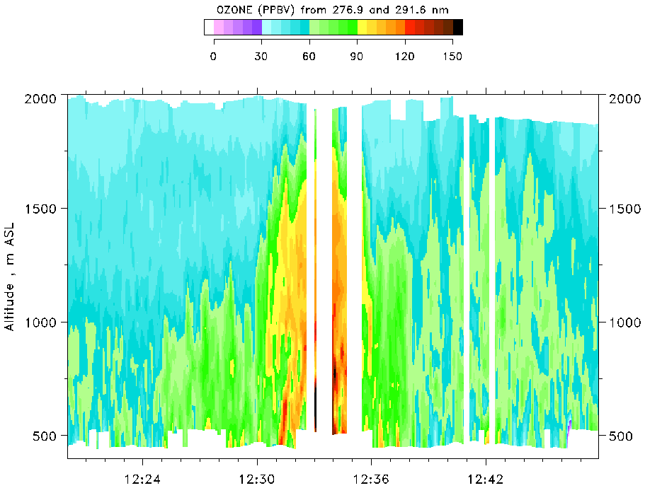
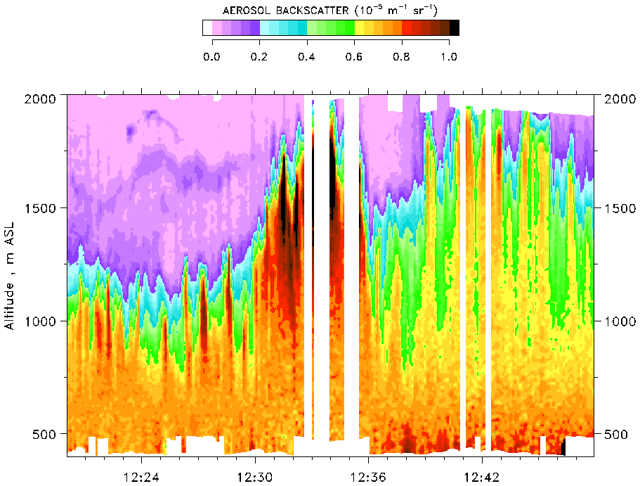
Figure A. Vertical cross sections of O3 concentration and aerosol backscatter for the NW-SE flight legs passing over Nashville for the afternoon flights on 12 July. (i) O3 concentrations (ppbV) for the first pass (1220-1248 CDT, (ii) aerosol backscatter (10-5 m-1 sr-1) for the first pass, and (iii) O3 concentration for the second pass (1405-1433 CDT).
Conditions that lead to the highest hourly photochemical ozone (O3) concentrations for a season in an urban area are light-wind conditions, in which pollutants accumulate near the source region. The very highest concentrations are expected during the lightest winds, i.e., during stagnation conditions. During the 1995 S.O.S. Nashville campaign, a 3-day stagnation episode occurred during mid July. Scientists obtained a rich dataset, including several very revealing flights from the ETL airborne O3 differential-absorption lidar (DIAL).
Key scientific questions included:
- How high in the atmosphere does the pollution reach during the day?
- Does pollution remain over the urban source region at night and thus accumulate over the several days of an episode, or does the pollution get blown away from the urban center?
- If the pollution does not remain over the urban area at night, what is its fate? does it become part of the rural background?
Data from the airborne O3 DIAL system allow us to address these issues. The data provide vertical cross sections of O3 concentration along the flight path of the aircraft. Intercomparison flights have shown that the O3 concentrations measured by the lidar agree with in situ aircraft measurements by 4 ppbv near the airplane and ~10 ppbv near the earth's surface (i.e., farther from the airplane).
Results:
- Daytime accumulation: Cross sections over the city on 12 July, the middle day of the 3-day episode [Figure A], showed that the urban pollutants formed a dome over the urban area. Significant O3 reached ~1.9 km above mean sea level (MSL; a mean elevation for the Nashville environs is ~200 m MSL), and O3 concentrations exceeding 120 ppb extended to >1.5 km MSL. A horizontal plot of O3 along the flight track [Figure B] shows that the pollution remained very close to Nashville.
- Nighttime wind behavior: winds near the surface remained light and variable at night, suggesting that the pollutant dome might stay put. Radar wind profiler data, however, show that the winds above ~100 m above ground level (AGL) accelerate at night. Because considerable pollution exists at these levels, this flow should transport the O3 away from the urban area at these heights. Overnight trajectories from the profiler data for the night between the first and second days of the episode [Figure C] show the expected effects of this transport. At lower levels between 250 and 500 m AGL pollution should be transported ~80 km to the west of the location of the pollution cloud at sunset.
- Early morning flights to the southwest of Nashville verified the presence of high O3 concentrations at lower levels. Figure D shows high O3 in the layer between 400 and 800 m MSL and superimposed trajectories. The trajectories are based on horizontally interpolated profiler winds averaged over the 400- to 800-m layer. At higher levels from 800 to 2000 m MSL, O3 concentrations were low.
- Vertical profiles of O3 from four successive identical flight legs over this region [Figure E] show the O3 mixing out in the vertical as the daytime mixed layer grows.
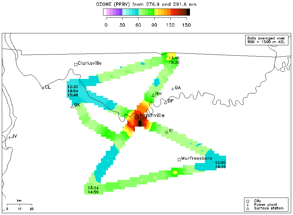
Figure B. Horizontal maps of the ozone distribution from the ozone lidar reveal the distinct increase in ozone concentrations (yellow, orange, red and black) over urban Nashville against the lower (blue and green) levels of the surrounding suburban and rural areas.

Figure C. Overnight forward trajectories calculated from the hourly horizontally interpolated winds, averaged over 400-m vertical intervals. Symbols indicate hourly positions beginning at 2000 CDT on July 11 and ending at 0800 CDT on July 12. Trajectory was calculated from an origin ~20 km southwest of Nashville at 36.0 N, 86.9 W.
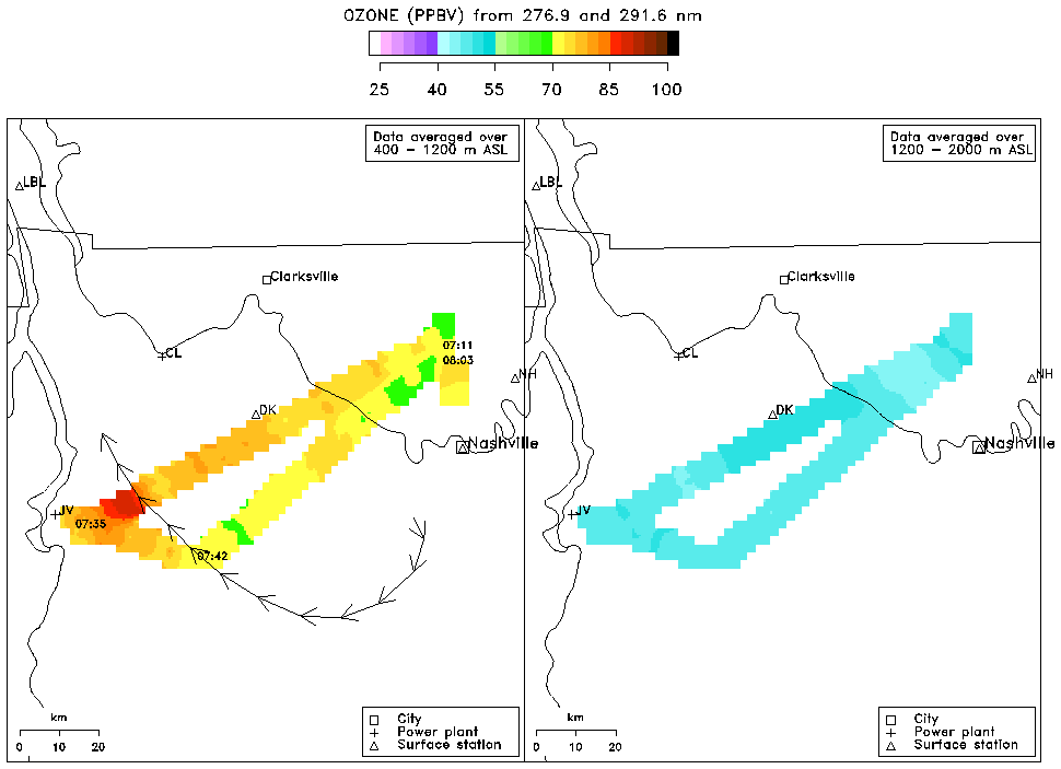
Figure D. Flight-track O3 data averaged over 800-m vertical intervals for the first flight track (0708-0805 CDT) on July 12: (a) lower level from 400 to 1200 m asl, and (b) upper level from 1200 to 2000 asl. Trajectory was calculated from mean winds in the 800 m layer from 400 to 1200 m asl.
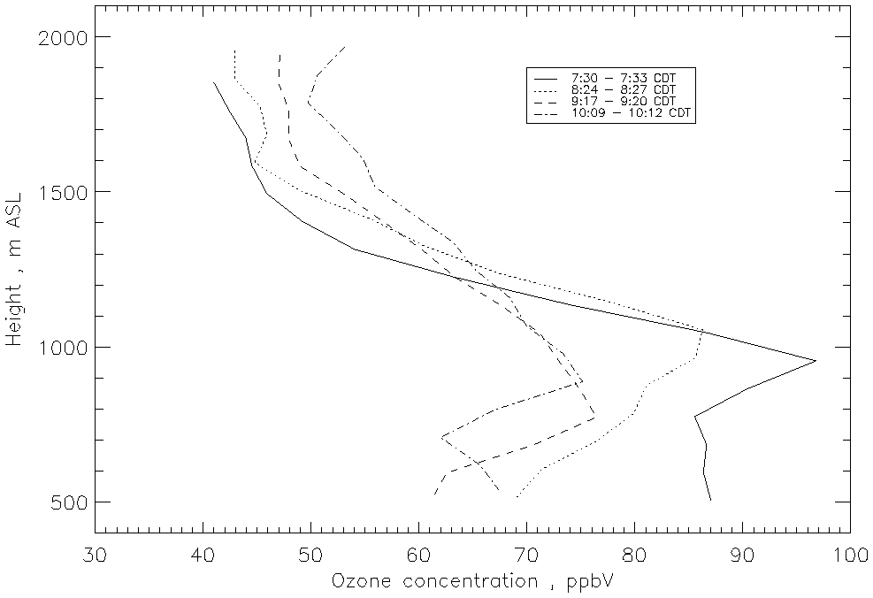
Figure E. Profiles of O3 averaged horizontally over the region of high O3 in the western part of the flight track shown in Figure D, for each of the four repetitions of the track during the morning flight on July 12.
Other interesting results:
- Differences in mixing layer height h between the area northwest of Nashville and the other quadrants around Nashville: differences of ~500 m in h could be seen over a few 10's of km [see aerosol cross sections in Figure A (ii); regions of high aerosol represent the mixed layer].
- Urban-rural differences in O3 concentration were highest on the lightest-wind day.
- The stagnation episode consisted of 3 days when the radar wind profilers showed light and variable winds throughout the depth of the daytime convective boundary layer. Even though the winds were light, the pollution cloud was observed to drift to varying degrees on the 3 days. This affected ground-level concentrations: the day with the least drift (12 July) had the highest O3 concentrations.
Conclusions:
O3 cross sections from airborne DIAL system have allowed us to address the questions above:
- During daytime the processes are relatively straightforward to interpret. Photochemical pollutants accumulate over or near the urban area and mix vertically to the top of the urban mixed layer, which may reach 2 km ASL.
- At night processes are more complex. Inertial accelerations of the winds in the layer that had been the previous day's mixed layer distribute pollutants from the urban pollution dome over the nearby countryside. Pollutants appear as patches or layers at different levels in the vertical for different directions of transport from the source.
- The layers or patches of urban pollution are mixed in the vertical the next day, as surface heating drives the growth of the daytime mixed layer.
These measurements have allowed us to characterize the fate of photochemical pollutants during a stagnation episode. As pollutants from the previous days' dome are mixing into today's rural background, a new pollutant dome is forming over the urban area.
Another important result of the light horizontal winds during stagnation is that local differences in land use can express themselves as local differences in mixing height h. On the middle day of the episode a difference of ~500 m in h was noted over a horizontal distance of a few 10's of km between the forested land to the west through northwest of Nashville and the farming and pasture land in the other directions around the city.
More details on all these issues can be found in Banta et al. (1998).