
Ground-based Measurements
East Texas experiences a complex diurnal cycle of meteorology caused by its proximity to the Gulf Coast, large urban areas and other heterogeneous land-surface types that produce local circulations, and varying synoptic regimes experienced during different seasons. A multi-season characterization of the meteorological processes controlling the stagnation and transport of atmospheric pollutants in and out of East Texas is, therefore, required in order to gain a better understanding of the region's air quality. The long-term meteorological measurements collected during TexAQS/GoMACCS will also allow scientists to study how the mixing and transport mechanisms outlined in Section 2b respond to diurnal, seasonal, and annual cycles.
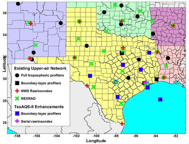
NOAA and partners in TexAQS/GoMACCS will enhance the Upper-air Network in central and southeastern Texas by deploying seven integrated boundary layer observing systems for a ~1.5 year extended observing period starting in April 2005. Included in the plans for this network is a wind profiler deployed on an oil platform in the Gulf of Mexico. The enhanced profiler network was designed to capture important transport corridors within East Texas. The 915-MHz Doppler wind profilers in the enhanced network are of the type described by Carter et al. (1995). These instruments provide continuous profiles of wind speed and wind direction in the boundary layer and lower free troposphere and derived mixing heights. Each land-based profiler will also include a radio acoustic sounding system (RASS) for temperature profiling. The vertical coverage of the wind profilers is typically 120 m to 4000 m, depending on atmospheric conditions, and the profiles are sampled with either 60-m or 100-m vertical resolution. The vertical coverage of the temperature profilers is typically 120 m to 1500 m, but degraded performance can be expected in high wind conditions. In addition, four of the profiler sites deployed by the NOAA Earth System Research Laboratory Physical Sciences Division (formerly the Environmental Technology Laboratory) will include a global positioning system (GPS) receiver for integrated water vapor measurements and a 10-m tower for characterizing surface meteorology (pressure, temperature, relative humidity, wind, precipitation, solar and net radiation). Additional profiler deployments may be added for the intensive observing period in 2006. During this period, serial rawinsondes will be launched (by non-NOAA participants) in the Houston area at a site to be determined.
Hourly data from the existing and enhanced wind profiler networks will be available in real-time via web sites hosted by NOAA. An interactive web-based profiler trajectory tool developed by the NOAA Earth System Research Laboratory Physical Sciences Division (formerly the Environmental Technology Laboratory) will also be available to help scientists document transport in the region and to help in the planning and execution of missions for the mobile platforms during the 2006 intensive.