Atmospheric Composition Modeling: Projects
Field Campaigns
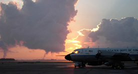
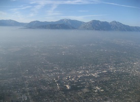
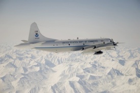
AiRMAPS, Colorado and Utah, Baltimore and Marcellus Shale, Texas and U.S. Southwest, Western U.S. O&G Basins, Marcellus Shale and Urban Midwest. Airborne and Remote sensing Methane and Air Pollutant Surveys (AiRMAPS) is a series of studies in 2024-2028 across the U.S. to provide comprehensive and quantitative top-down emissions data for methane, other greenhouse gases (GHGs), and major air pollutants from oil and gas (O&G) production basins, and selected urban and agricultural areas. NOAA OAR and NESDIS lead this investigation of greenhouse gas and air pollutant emissions and impacts. More Info

AIQ, New York City. Air (Ine)quality in New York City is a pilot project to map surface ozone and PM2.5 in underserved boroughs in New York City during heat wave events and to engage with their communities in Summer 2023. Researchers from CSL and the City College of New York (CCNY) conduct the study to demonstrate the connection between detailed ground level observations, where pollution directly impacts human health, and the broader aircraft and satellite observations deployed under AEROMMA. More Info

AEROMMA, Coastal U.S. megacities. Atmospheric Emissions and Reactions Observed from Megacities to Marine Areas (AEROMMA) addresses emerging research needs in urban air quality, marine chemistry influences on cloud formation, and interactions at the marine-urban interface. Researchers will investigate anthropogenic and marine emissions that alter tropospheric composition and impact air quality and climate from science flight and ground site activities based in Palmdale, California, Dayton, Ohio, and the NYC metro area during Summer 2023. CSL is engaged with flight planning and forecast modeling for the summer campaign. More Info

FIREX-AQ, Western U.S. Fire Influence on Regional to Global Environments and Air Quality (FIREX-AQ) is a NOAA / NASA interagency intensive study of North American fires during the 2019 wildfire season. The project combines the previously separate NASA FIREChem and NOAA FIREX aircraft campaigns to better study the atmospheric effects of wildland and agricultural fires in the U.S. This offers significant advantages to the research community by optimally leveraging the scientific interests, personnel, and assets of NASA, NOAA, other agencies, and academic partners in a fully integrated program of field measurements, modeling, and interpretation. More Info

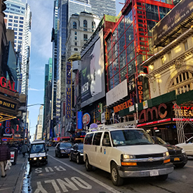
NYICE, New York City metro. Researchers drove an instrumented van (our Mobile Laboratory) into New York City for the New York Investigations of Consumer Emissions (NYICE) project in March 2018. Investigators were particularly interested in volatile organic compound (VOC) emission source areas in and around the New York City (NYC) metropolitan area (comprised of portions of New Jersey, New York, and Connecticut in and around NYC). Researchers parked the mobile lab at City College of New York, taking measurements among a dense population as a ground site. In addition, researchers acquired data during daytime drives up and down Manhattan, staying close to Times Square at morning and evening rush hour, and around the metro area. They returned in July 2018 for measurements during the summer season. More Info
POSIDON, Guam. The Pacific Oxidants, Sulfur, Ice, Dehydration, and cONvection (POSIDON) Experiment is a focused airborne science mission to study the ozone distribution, sulfur chemistry, very short-lived ozone depleting species (VSLS), cloud microphysics, and dehydration in the tropical upper troposphere and lower stratosphere over the western Pacific. Instrumentation aboard the NASA WB-57F deploys in the fall 2016 to Guam. CSD and GMD federal and cooperative institute (CIRES) researchers and engineers have designed, built, and installed five of the 12 instruments and all of the balloon packages. Flight planning and meteorology/forecasting products provided by NASA and CSD. More Info

AeroMarine, La Réunion. The AeroMarine project was an international collaborative effort between NOAA (USA) and OSU-Réunion and LACy laboratory (France). The Southern Indian Ocean is potentially a hot spot for sea spray emission due to strong trade winds and high sea surface temperature. Hence, measurements taken from La Réunion are relevant for several topics related to marine aerosols and pristine oceanic regions. CSD deployed the POPS (Printed Optical Particle Spectrometer) instrument to La Réunion to observe marine aerosols during a two week field campaign in March 2016. More Info
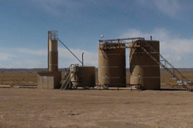
SONGNEX, Western U.S. The goal of the Shale Oil and Natural Gas Nexus (SONGNEX) 2015 program is to quantify the emissions of trace gases and fine particles from several different tight oil and shale gas basins in the western U.S., and to study the chemical transformation of these emissions. The study focuses on basins which represent a mixture of oil and gas production regions at various stages of development. This airborne study involves the NOAA WP-3D aircraft mobile platform. More Info
FRAPPÉ / DISCOVER-AQ, Colorado Front Range. The NSF sponsored Front Range Air Pollution and Photochemistry Éxperiment (FRAPPÉ) and the NASA sponsored Deriving Information on Surface conditions from Column and Vertically Resolved Observations Relevant to Air Quality (DISCOVER-AQ) mission take place in Summer 2014. Three aircraft, including the NASA P-3 and King Air and the NSF / NCAR C-130 make observations characterizing the local to regional chemical environment including photochemistry, oxidant and aerosol formation and fate, flow and recirculation patterns and large-scale inflow. Instruments at the Boulder Atmospheric Observatory (BAO) tower provide both ground-based measurements and vertical profiles of a suite of compounds that contribute to aerosol and ground level ozone. More Info
SENEX, Southeast U.S. The goal of the Southeast Nexus (SENEX) 2013 program is to study the interactions between natural and anthropogenic emissions in the southeast at the nexus of the air quality and climate change. Scientists quantify the emissions of greenhouse gases and aerosol, and investigate the roles played by anthropogenic and natural emissions in the formation of ozone and aerosol in the atmosphere. This airborne study involves the NOAA WP-3D aircraft, forecast modeling and surface monitoring networks. More Info
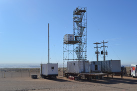
E&E UBWOS, Horse Pool, Utah. The Energy and Environment - Uintah Basin Winter Ozone Study (E&E UBWOS) was designed to study the causes of high wintertime ozone observed in the Uintah Basin. Scientists constructed a ground site of instruments in the winters of 2012, 2013, and 2014 to study sources of VOCs, NOx and particles, ozone formation chemistry in areas of enhanced UV radiation from snow cover, unique radical sources (HONO, CH2O, ClNO2) and the role of transport. More Info
DC3, Salina, Kansas. The Deep Convective Clouds & Chemistry (DC3) experiment investigates the impact of deep, midlatitude continental convective clouds, including their dynamical, physical, and lightning processes, on upper tropospheric composition and chemistry. Airborne measurements taken from the NASA DC-8 in July 2012 provide in situ observations to characterize the convective storm inflow and provide remote sensing to aid in flight planning and column characterization. More Info
CalNex, Southern California. The goal of the California Research at the Nexus of Air Quality and Climate Change (CalNex) 2010 program is to study the important issues at the nexus of the air quality and climate change problems, and to provide scientific information regarding the trade-offs faced by decision makers when addressing these two inter-related issues. The NOAA WP-3D aircraft, the R/V Atlantis ship, and several ground sites were involved in this project. Comprehensive data analysis followed the completion of this project in July 2010. More Info
ARCPAC, Fairbanks, Alaska. As part of the International Polar Year of 2008, NOAA engaged in an airborne field measurement campaign targeted at improving understanding climate-relevant processes. The Aerosol, Radiation, and Cloud Processes affecting Arctic Climate (ARCPAC) effort was focused on direct measurements of properties and processes that can be used to reduce uncertainty in radiation and climate models. The measurements were made in the Alaskan Arctic to closely coordinate with remote-sensing and in situ observations planned for aircraft and ground sites in the vicinity of Barrow, Alaska. Field support operations in collaboration with NASA's Arctic Research of the Composition of the Troposphere from Aircraft and Satellites (ARCTAS) based out of Fairbanks, Alaska. More Info
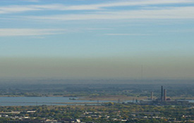
TexAQS 2006, Houston, Texas. This intensive field study focused on providing a better understanding of the sources and atmospheric processes responsible for the formation and distribution of ozone and aerosols in the atmosphere and the influence that these species have on the radiative forcing of climate regionally and globally, as well as their impact on human health and regional haze. The Texas Air Quality Study (TexAQS) area included Texas and the northwestern Gulf of Mexico in the summer of 2006. This project used the NOAA WP-3D and the R/V Ronald H. Brown as research platforms. More Info