Atmospheric Remote Sensing: Instruments
Tunable Optical Profiler for Aerosol and oZone (TOPAZ) lidar
The Tunable Optical Profiler for Aerosol and oZone lidar (TOPAZ) lidar was designed and built in 2006 at the NOAA Chemical Sciences Laboratory. TOPAZ incorporates state-of-the-art technologies to make it compact and lightweight as well as having low power consumption. These features have allowed for flexibility in its application to numerous air quality field studies, both airborne and ground-based. Its wavelength flexibility permits optimization for differing atmospheric conditions including interference from other atmospheric components and allows dual-DIAL operation – introduction to Differential Absorption Lidar (DIAL) techniques.
TOPAZ was originally configured and deployed on the NOAA Twin Otter aircraft to participate in air quality studies where it provided wide-area mapping of ozone and aerosol distributions and transport near urban sources. The first example of this application was the Texas Air Quality Study (TexAQS) 2006. As the lidar was flown over and around the Houston area collecting ozone and aerosol backscatter profiles from flight level to near ground level, it produced a three-dimensional picture of the distribution of ozone and aerosols in the study area. Additional information obtained from the lidar data included boundary height determination and ozone plume flux measurements.
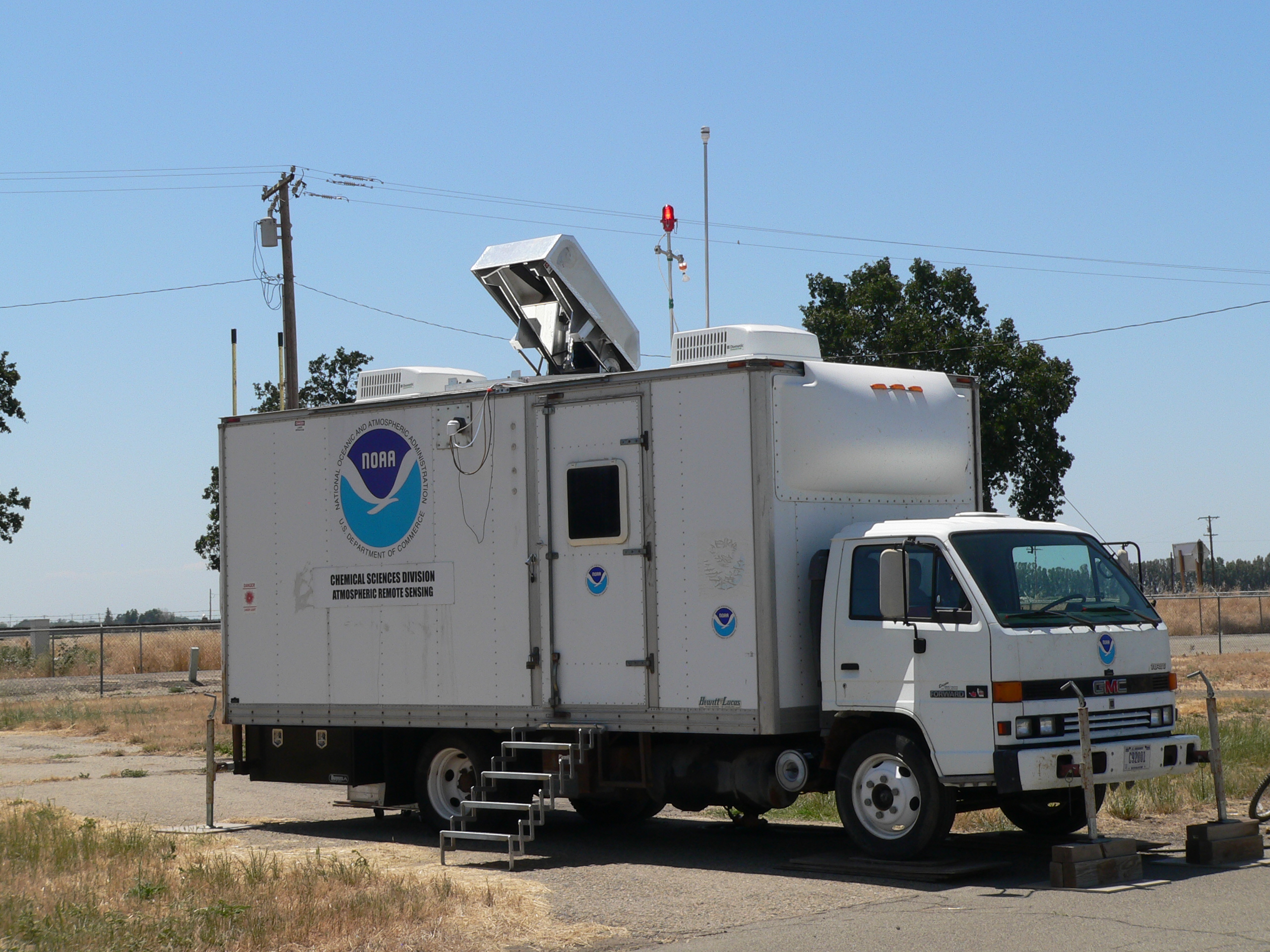
After several years of airborne operation, TOPAZ was reconfigured for deployment in a box truck (and, more recently, a trailer) for ground-based operation. The addition of a two-axis (one automated) scanner permits data collection from a few meters above ground level (AGL) through 6-8 km AGL, dependent on atmospheric conditions. Recent examples of TOPAZ applications in this arrangement include the California Baseline Ozone Transport Study (CABOTS) 2016 and the Fires, Asian, and Stratospheric Transport - Las Vegas Ozone Study (FAST-LVOS) 2017 experiments.
TOPAZ is also part of the NASA Tropospheric Ozone Lidar Network (TOLNet) for ground-based profiling of tropospheric ozone. In addition to the occasional deployment to field experiments, TOPAZ makes routine measurements in support of TOLNET goals including satellite ozone measurement validation and creating a long-term ozone measurement record under varied atmospheric conditions on the Front Range of Colorado.
Basic Parameters Measured
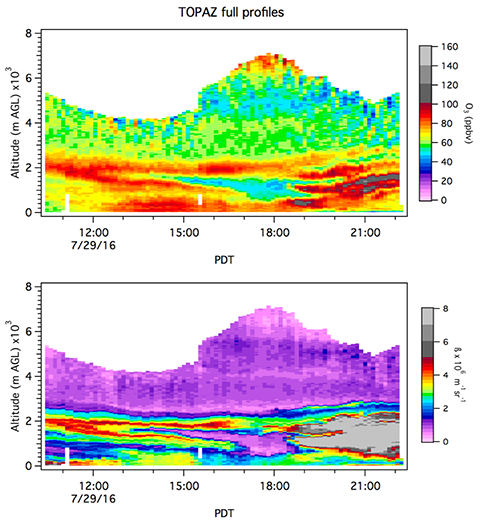
- Ozone concentration profiles
- Aerosol backscatter profiles
Typical Specifications
| Output | Near-real-time ozone and aerosol profiles uploaded to NOAA CSL website |
| Tuning range | 285-310 nm (three wavelengths) |
| Pulse energy | 0.04 - 0.06 mJ/pulse |
| Pulse rate | 1 kHz with pulse-to-pulse tuning capability (333 Hz for each individual wavelength) |
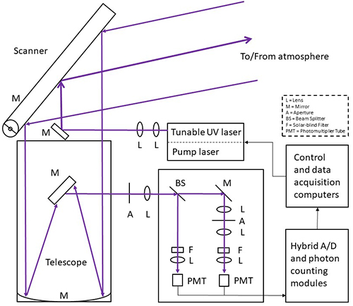
| Laser | Diode-pumped Nd:YLF laser quadrupled in LBO (intracavity) and CLBO (external) to 262 nm to pump Ce:LiCAF in a tunable cavity |
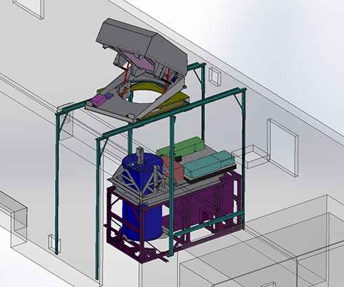
| Receiver | 0.5 m Newtonian telescope with two-axis (one automated) scanner |
| Digitizer | Hybrid analog-to-digital and photon counting transient recorder modules (16 bits, 20 MHz A/D sample rate, 250 MHz count rate) |
| Maximum profile altitude | 6 - 8 km above ground level (AGL) |
| Minimum profile altitude | ≤ 5 m AGL (minimum height limited by safety and/or terrain) |
| Eye-safe range | 150 m |
| Trailer dimensions | 32' L x 8.5' W x 11' H |
| Trailer shore power | 120/240 VAC 100 A service |
| Ozone profile vertical resolution | 5 m near surface to 1000 m at 8 km AGL |
| Ozone concentration accuracy | ≤ 2 ppbv |
| Ozone concentration precision | 3-10 ppbv (increasing with altitude and dependent on ozone and aerosol concentrations) |
| Auxiliary equipment | In situ ozone sampling (2B instrument), Weather station |
Field Projects
| Project Name | Date | Location | |
|---|---|---|---|
| CUPiDS 2023 | Coastal Urban Plume Dynamics Study | Summer 2023 | Guilford, Connecticut (ground site) |
| COVID-AQS 2020 | COVID Air Quality Study | Spring 2020 | Boulder, Colorado (ground site) |
| FAST-LVOS 2017 | Fires, Asian, and Stratospheric Transport - Las Vegas Ozone Study | May - June 2017 | Las Vegas, Nevada (ground site) |
| SCOOP 2016 | Southern California Ozone Observation Project | August 2016 | southern California (ground site) |
| CABOTS 2016 | California Baseline Ozone Transport Study | June - August 2016 | Visalia, California (ground site) |
| DISCOVER-AQ 2014 | Deriving Information on Surface conditions from Column and Vertically Resolved Observations Relevant to Air Quality 2014 | July - August 2014 | Erie, Colorado (ground site) |
| DISCOVER-AQ 2013 | Deriving Information on Surface conditions from Column and Vertically Resolved Observations Relevant to Air Quality 2013 | September 2013 | Houston, Texas (ground site) |
| LVOS 2013 | Las Vegas Ozone Study | May - June 2013 | Angel Peak, Nevada (ground site) |
| UBWOS 2013 | Uintah Basin Winter Ozone Study 2013 | January - February 2013 | Horsepool, Utah (ground site) |
| UBWOS 2012 | Uintah Basin Winter Ozone Study 2012 | February 2012 | Horsepool, Utah (ground site) |
| CalNex 2010 | California Research at the Nexus of Air Quality and Climate Change | May - July 2010 | Southern California (Twin Otter, aircraft based) |
| FRAQS 2008 | Front Range Air Quality Study | July - August 2008 | Colorado Front Range (Twin Otter, aircraft based) |
| TexAQS 2006 | Texas Air Quality Study 2006 | August - September 2006 | Houston, Texas (Twin Otter, aircraft based) |